Land off
Huddlesford Lane
Whittington, Lichfield
Land off
Huddlesford Lane
Whittington, Lichfield
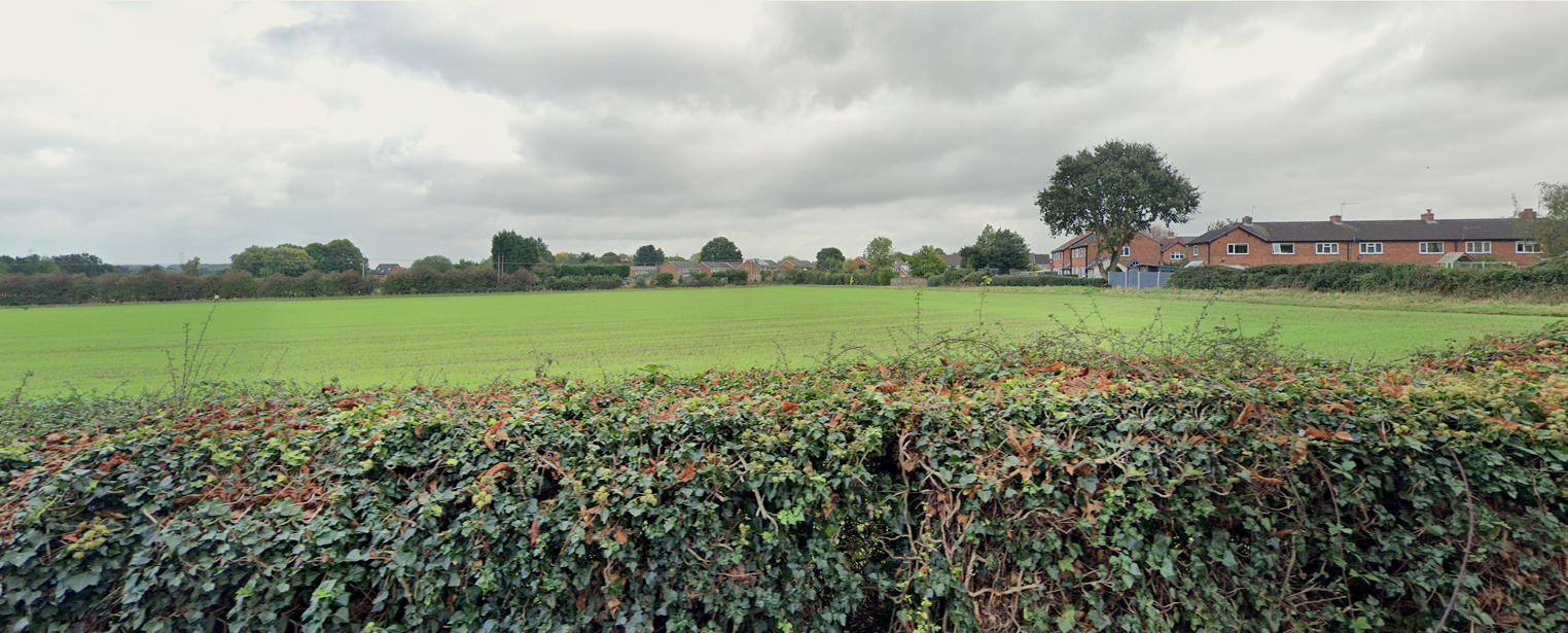
Richborough, a land promotor, seeks your views on proposals for residential development on land off Huddlesford Lane, on the north-western settlement edge of Whittington in Lichfield District.
About Richborough
The Site
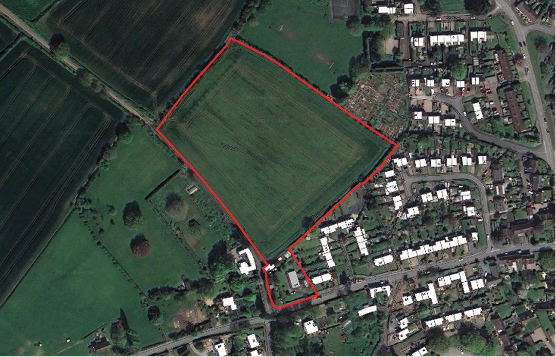
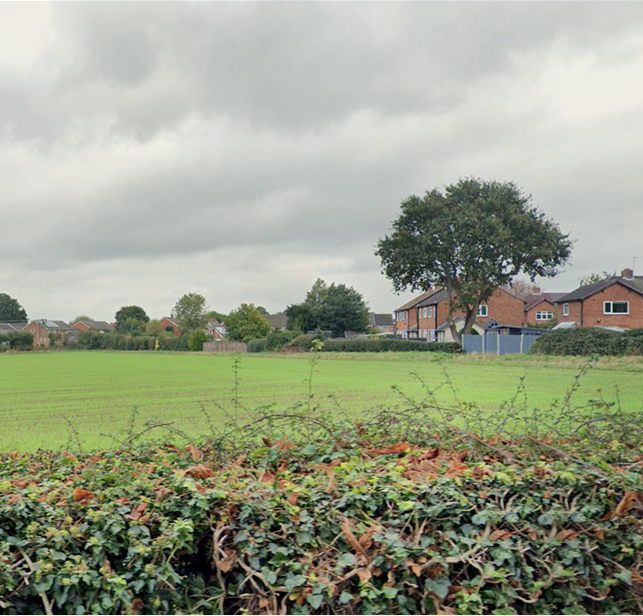
The site comprises a single agricultural field in arable use, equating to approximately 2.93 hectares. The site is relatively flat and located on the north-western edge of the village of Whittington.
The site is defined by Huddlesford Lane to the west, village allotments and Swan recreation ground to the east, the existing residential area of the village to the south, along Back Lane and Pass Avenue and open countryside to the north. The Coventry Canal lies to the north of the site and passes through the village to the north. Boundaries of the site are defined, in the main, by hedgerows interspersed by trees.
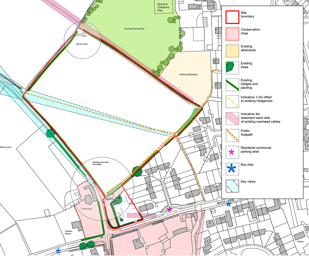
There are several factors that the site will have regard to:
- Hedgerow and hedgerow trees located along the site’s northern, eastern and western boundaries
- Respecting the local character and situation of the site on the north-western edge of Whittington
- New publicly accessible open space that will provide an appropriate transition from the village settlement to the countryside
- Biodiversity enhancement through the creation of new and improved habitats and green space
- Protecting the amenity of existing residents adjacent to the site including homes on Back Lane and Pass Avenue.
There are several opportunities present as follows:
- Potential additional parking to serve existing properties on Back Lane who currently do not have access to off-street parking. This will assist in reducing the level of on-street parking experienced on Back Lane
- Realignment of Huddlesford Lane and a new junction with Back Lane including the downgrading of the southern part of the existing Huddlesford Lane to form an additional public footway from the village into the wider countryside
- Connections to existing public rights of way within the village and wider area
- The majority of existing hedgerows can be retained and strengthened
- Ability to deliver a minimum 10% Biodiversity Net Gain
- Contribute to the need for 2- and 3-bedroom properties within the District
- Provide affordable housing for the area, particularly addressing the areas shortfall of affordable homes in the Districts rural areas.eation areas.
Policy Context
Government Policy
The National Planning Policy Framework (NPPF) requires local planning authorities to have an up-to-date local plan to shape how land use and places will change and develop in the future. The planning system is intended to be genuinely plan-led. Local Plans are required to provide a positive vision
for the future of each area; a framework for addressing housing needs and other economic, social and environmental priorities; and a platform for local people to shape their surroundings. Local Plans must support the delivery of enough homes to meet housing needs including a 5 year supply of oven ready sites. Housing needs for a particular local authority area are established through a standard formula set by Government.
Development Plan
Lichfield District Council is currently unable to identify a five year supply of oven ready housing sites, rendering the Local Plan policies relating to housing supply as out of date. Additional housing sites are therefore required to meet local housing needs within the District.
Whittington lies within the designated Whittington & Fisherwick Neighbourhood Area. A Neighbourhood Plan for the area was adopted in April 2018. The Parish Council is in the process of updating and reviewing its neighbourhood plan.
The plan provides support for residential development within the village which meets local needs. The neighbourhood plan does not seek to allocate sites to meet local needs.
What is being proposed?
Richborough is preparing an outline planning application for this site.
An outline planning application establishes the broad principles of development, such as the number of new homes, open spaces, access arrangements and design principles.
If approved, subsequent reserved matters applications will be submitted providing further detail in respect of the design of homes and landscaping.
Homes
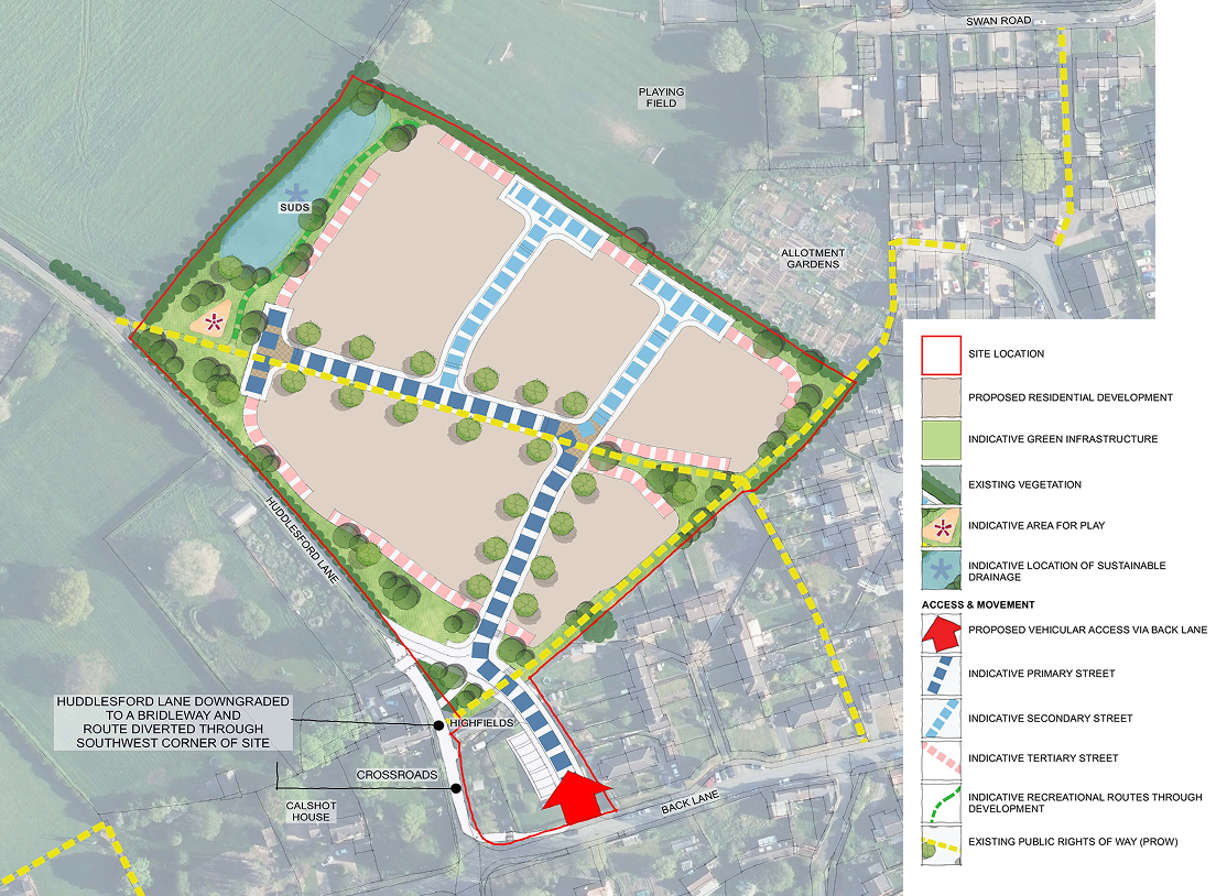
The outline proposal includes the construction of approximately 70 new dwellings, including the provision of affordable homes in line with Lichfield District Council policy and the Government’s ‘Golden Rules’. This will make a substantial contribution to addressing identified local housing needs.
A range of housing types, sizes and tenures ensures the creation of a balanced and cohesive community that is representative of the local population. It is understood that there is a need for smaller homes that would suit first time buyers or down-sizers who want to remain or return to the village.
43% of homes will be affordable including social rented, shared ownership or discounted market properties to meet the needs of those on lower incomes
All dwellings would include parking in line with Lichfield District Council’s parking standards.
Access
The proposed site access junction will take the form of a new priority T-junction off Back Lane c.40m east of the existing Back Lane/Huddlesford Lane/Chapel Lane junction. This will also incorporate a diversion and downgrade of Huddlesford Lane.
The proposal will downgrade a c.70m length of Huddlesford Lane carriageway, between the Highfields dwelling to the Back Lane/Chapel Lane junction, to a bridleway for pedestrians, cyclist and equestrians; with access to the existing dwellings being taken from the new section of Huddlesford Lane to the east.
This proposal allows for the Back Lane/Chapel Lane junction to be amended from the current priority crossroads layout, to a new simple priority T-junction layout incorporating a speed reduction bend between Back Lane and Chapel Lane.
The proposal retains the give-way on the Back Lane approach to the junction from the west, amending the priority via a speed-control bend between Back Lane (from the east) and Chapel Lane.
The amendments to the junction arrangement result in an improved visibility from the western Back Lane approach arm; whilst the speed-control bend will ensure slow speeds are maintained through the junction and a 17m forward visibility splay is provided around the bend, which is appropriate for a 15mph design speed.
land off Huddlesford Lane, Whittington
Open Space
The green infrastructure network proposed throughout the site will ensure people have an accessible space to meet, exercise, relax and play. The proposal creates a series of linked open spaces to integrate the transition to the countryside and provide an enhanced network of footpaths.
All existing hedgerows and trees around the site will be retained where possible. There will also be new tree and hedgerow planting throughout the development to soften the transition between the village and the open countryside.
Flood Risk & Drainage
The site is located within Flood Zone 1, which has the lowest probability of flooding.
Any future planning application will be supported by a flood risk assessment to consider flood risk from all sources and to ensure development does not increase flood risk elsewhere. A drainage strategy will also be prepared, detailing how surface water from the site will be successfully controlled.
The development will utilise Sustainable Drainage System (SuDS) to deal with surface water. This will include a new attenuation pond. The location of the pond has been determined by site topography.
Local Infrastructure
On site provision and/or financial contributions will be provided towards local infrastructure to mitigate any impact of the development. These contributions will be secured through a legal agreement. Any on site infrastructure or off-site financial contributions will be finalised through a planning application following discussions with Lichfield District Council and other infrastructure providers.
This will consider capacity at local facilities such as schools and GP practices.
The proposed development will provide up to 43% affordable housing, new pedestrian and highway linkages and a new area of car parking for immediate neighbours on Back Lane, to improve the current on-street parking.
The development will pay the Community Infrastructure Levy (CIL) with a proportion of 25% of monies collected being passed to the Parish Council.
The Design Approach
The design of the proposal has been informed by a number of constraints and opportunities including the presence of trees and hedgerows, longer-distance views of the site and the need to protect the amenity of residents, including existing neighbours to Back Lane and Pass Avenue.
The key design principles are as follows:
- Development set back from the site boundaries and creation of new landscaped edge to the north and west to maintain a soft transition into the countryside
- Retention of existing trees and hedgerows and provision of new wildlife corridors and open space to deliver a net gain in biodiversity
- Provision of layout arrangement within the site to foster low speed vehicular movement
- A density of development that reflects the character of the village and complies with the District Council’s adopted Design Code for the area
- A green infrastructure network that creates a series of linked open spaces and softens the visual impact of the development and provide recreational benefit to the wider community
- New and enhanced pedestrian linkages throughout the site to the village and the wider countryside beyond
- Realignment of Huddlesford Lane and creation of parking area for existing residents to provide improvements to traffic movements along Back Lane and the local highway network
- The provision of a range of house types, sizes and tenures to contribute positively to the quality and character of the new development and reflect the local vernacular
- Ensuring all homes have policy compliant parking which are positioned not to dominate the development and reduce the need for street parking.
Planning Application & Next Steps
Richborough are preparing an outline planning application for the site.
An outline planning application establishes the broad principle of development, such as the number of new homes, open spaces, illustrative masterplan and access arrangements.
We would welcome your comments and feedback on the emerging proposals via our questionnaire below as we finalise our outline plans ready for submission to Lichfield District Council.
Once the planning application is submitted, there will be further opportunity to comment through the statutory consultation period conducted by the council as it considers the outline planning application.
If outline consent is granted, a detailed planning application would be prepared called a reserved matters application. This would include more detail such as architecture, materials, detailed layout and landscaping, and would be subject to further consultation with the local community prior to submission of the application.
This would provide the community with another opportunity to provide input to ensure that the detail of the new development further reflects local needs and aspirations.
Feedback
We would welcome your comments on any part of the development proposals. To send us your comments, please complete the short questionnaire below.
These must be returned by Friday 5th September 2025
What happens next?
We will consider all the feedback and suggestions as part of this consultation and use them to help shape the proposals for this site. A further consultation will be undertaken once an application is submitted.

